This item has closed 1 buyer bought 1 item
View other items offered by antiquemaps190

Similar products

R30 shipping
1922 Map of South Africa - Eastern Section, fair Condition, Original Bartholomew Map
R125
R30 shipping
25% OFF
SCARCE Map 1879 South Africa.Thomas Brumby Johnson
R3,750 R5,000
Vintage Railways Map of South Africa 1946 1 x Map Digital Download
R245
R30 shipping
Special map of The Union of South Africa and South West Africa (large)
R450

1750 Map of South Africa - Le Pays Des Hottentots

Secondhand
R1,675.00
Shipping
Standard courier shipping from R30
R30 Standard shipping using one of our trusted couriers applies to most areas in South Africa. Some areas may attract a R30 surcharge. This will be calculated at checkout if applicable.
Check my rate
Ready to ship in
The seller has indicated that they will usually have this item ready to ship within 3 business days. Shipping time depends on your delivery address. The most accurate delivery time will be calculated at checkout, but in general, the following shipping times apply:
 
Standard Delivery
Main centres:  1-3 business days
Regional areas: 3-4 business days
Remote areas: 3-5 business days
Buyer Protection How you're covered
Get it now, pay later

Product information

Discreet item
Condition:
Secondhand
Location:
South Africa
Customer ratings:
Bob Shop ID:
39451770

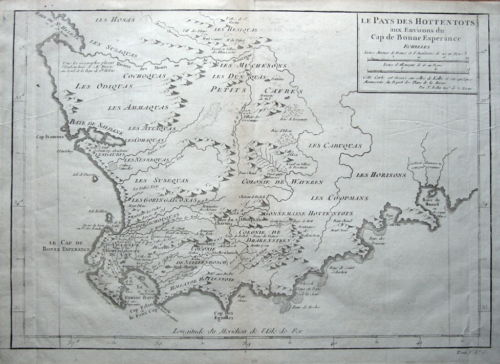
LE PAYS DES HOTTENTOTS

Aux Environs du Cap de Bonne Esperance

Published Paris c1750 by Jacques Nicolas Bellin.


An 18th century copper engraved chart of South Africa depicting the various Hottentot and other tribal areas around the Cape of Good Hope. Bellin's usual coastal detail includes rocks, shoals and anchorages.


  Fine condition other than some printing creases and faint toning around the centre fold line.  Fold lines as issued, blank verso.


Approx. 370mm x 270mm) on a medium grade hand laid paper.

Jacques Nicolas Bellin (1703 -1772) was chief cartographer to the French Navy and Hydrograhic office (Depot de la Marine). He produced many fine maps and seacharts in such publications as the "Atlas Maritime", and the "Hydorographie Francaise". He published 580 smaller format charts in the "Petit Atlas Maritime" and contributed many maps to Prevost's "Histoire Generale des Voyages". Noted for painstaking accuracy and fine workmanship his influence spread far beyond his native France. 

FREE DOMESTIC SHIPPING IN A TUBE

Customer ratings: 1 ratings

Great service, prompt delivery, gorgeous map
17 Jul 2011